The IMD chief also allayed fears of occurrence of an El-Nino.

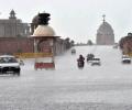
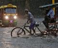
Incessant rains continued to lash Mumbai city and neighbouring districts on Saturday, throwing normal life out of gear even as weathermen predicted heavy showers across the state for Sunday.

The national capital on Friday recorded a 24-hour average air quality index of 239. On Thursday, it was 315, the worst since February 12 when the AQI was 320.
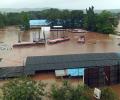
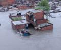
Major rivers in Ratnagiri district, including Jagbudi, Vashishti, Kodavali, Shastri, Bav are flowing above the danger level. As a result, Khed, Chiplun, Lanja, Rajapur, Sangameshwar towns and nearby areas have been affected and residents are being shifted to safer places.

A below-normal monsoon is likely to drag down the food output with India's agricultural GDP growth likely to slump to 0.8 pc in the current fiscal, says a report by the Japanese brokerage firm Nomura.

The weather department said its latest model analysis had indicated that the moist easterly winds in the lower level from the Bay of Bengal would spread to northwest India, covering Punjab and Haryana by July 10, leading to the advancement of monsoon and an increase in rainfall activity over the region, including Delhi, from July 10 onwards.

According to the India Meteorological Department (IMD), the Ayanagar weather station recorded 99.2 mm rainfall, the maximum in the city, during the 24-hour period ending at 8.30 am on Thursday.

Incessant showers caused landslides and floods in various parts of the country leaving at least 17 people dead on Wednesday while thousands more were forced to move to safety as rivers swelled and water reservoirs filled up fast.

The city also recorded a maximum temperature of 23.8 degrees Celsius, 16 notches below normal and the lowest in the month of May since 1951, the IMD said.

The dip in the air quality can be attributed to low wind speed and temperatures which allowed accumulation of pollutants.

Moderate to heavy showers will continue over Mumbai for next 48 hours.

Kashmir Valley on Thursday experienced fresh snowfall with most places, especially the plains, witnessing the first snow of the season, breaking the prolonged dry spell at the fag end of 'Chillai-Kalan', the 40-day period of harshest winter. While the snowfall was mild and brief, it nonetheless brought much joy to the locals.

Data spanning the years 1951 to 2014 show that temperature and pressure conditions at specific locations in the Arctic region during the pre-monsoon period correlate with the Indian summer monsoon rainfall, points out Charu Bahri.

"The season averaged maximum temperatures in Himachal Pradesh, West Rajasthan, Konkan, Goa, Coastal Karnataka, Kerala and Arunachal Pradesh are likely to be higher than normal by 0.5-1.0 degree Celsius," the Met department has said in its forecast.

Prime Minister Narendra Modi on Thursday reviewed the preparedness to deal with the situation arising out of the likely formation of Cyclone Jawad that is expected to hit the North Andhra Pradesh-Odisha coast and directed officials to take every possible measure to ensure that people are safely evacuated.

As per the India Meteorological Department many districts in Maharashtra recorded maximum temperatures of 40 degree Celsius or above in the last two days.
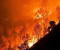
The reasons behind a spate of forest fires in the hills this year, though, could be multi-fold.
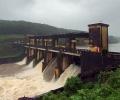
After a review meeting held at the Pathanamthitta District Collectorate to assess the situation, Rajan and state health minister Veena George said at a press conference that it has been decided to open the Kakki dam to release around 100-200 cumex water which would increase the water level of Pampa river by around 15 centimetres.

An alert of "very heavy" rainfall in Mumbai has been issued by the Indian Meteorological Department's regional centre on Tuesday, with the rains expected to intensify in the next 24 hours.

A low-pressure area, set to form over east central Bay of Bengal on May 22, is likely to intensify into a cyclonic storm and strike the Odisha-West Bengal coast on May 26, the Met department said on Thursday, sparking fears of another Amphan-like catastrophe.

Other Graded Response Action Plan measures like ban on diesel generators, hot mix plants, stone crushers and brick kilns, however, continue to remain in place.

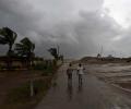
An estimated 1.5 lakh people are being shifted from low-lying coastal areas in Gujarat while 54 teams of the NDRF and SDRF remained deployed on Sunday in view of the India Meteorological Department's (IMD) warning that the very severe cyclonic storm Tauktae will reach the state coast on Monday evening and cross it on early Tuesday morning.

IMD expects day temperatures to remain above-normal in select regions across the country between March and May 2021.

Kerala State Disaster Management Authority has warned about the possibilities of landslides in the hilly areas already hit by extremely heavy rainfall in the past few days and directed people living in the region and government authorities to be vigilant.

Suburban services were disrupted with trains on all the three lines -- western, central and harbour -- running late.

Hail and rainstorm killed 160 people in 11 provincial regions, mainly along the mighty Yangtze River and its distributaries, and have left 28 missing, state-run Xinhua news agency reported.

The weather office on Monday forecast heavy to very heavy rainfall over the next three days over some parts of Uttarakhand, which is still recovering from a deluge last week that is feared to have taken over 1,000 lives.
Meanwhile, Prime Minister Narendra Modi expressed anguish at the loss of lives in Uttarakhand and noted that rescue operations are underway to help the affected.

The Centre will review the situation on a fortnightly basis.

Schools and colleges, closed since October 31, were shut on Saturday as well, while several universities postponed their exams.

The Ayanagar weather station recorded 122.8 mm between 8.30 am on Wednesday and 8.30 am on Thursday, which was 11 times the normal rainfall.

While weather forecasters remain divided on how the monsoons will play out in India over the next few months, analysts believe the news at the current juncture - at best - can trigger a knee-jerk reaction in the markets. They believe it is too early to say whether the sub-par monsoon on account of El Nino can seriously dent the market sentiment in the short-to-medium term. "These are just initial forecasts and we will have another round / status update from the weather forecasters a month down the line.

The system moved north-northeastwards at 20 kmph in the last six hours and is over west-central Bay of Bengal, 90 km from Gopalpur, 120 km from Puri and 210 km from Paradip, the weather office said in its 11.30 am bulletin.
The IMD has warned of squally winds speed reaching 45-55 kmph gusting to 65 kmph likely to commence along and off Odisha and north coastal Andhra Pradesh coasts from October 27 onwards.
Steady progress in June; north and central regions to get good pre-showers

Leh in Ladakh region recorded the lowest temperature this winter as mercury plummeted to minus 17.1 degree Celsius on Tuesday night, a meteorological department official said.

Heavy falls at isolated places are very likely over Kerala on April 29 and 30. The system will not make landfall in Tamil Nadu, but may bring light rain in some northern parts, it said.

Exactly a year after the very severe cyclonic storm Phailin struck the state, another storm is heading towards the Odisha coast.

About 4.41 lakh rural habitations are facing drinking water scarcity and the government is closely monitoring the drought situation on a daily basis in 10 states, Agriculture Minister Radha Mohan Singh said on Saturday.

The Indian Meteorological Department, meanwhile, warned of intense spell of 30 to 50 mm rainfall per hour with strong winds in Mumbai and suburban areas.